Colorado River Health Assessment Framework
Colorado Water Conservation Board
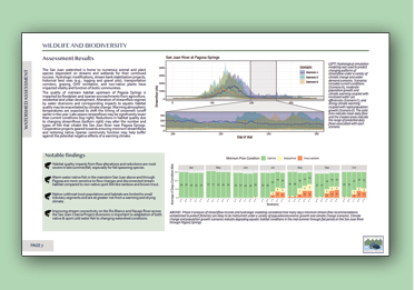
Assisted in the development of Colorado River Health Assessment Framework (CoRHAF) guidance documents and worksheets. Developed, designed and published a website containing CoRHAF materials. Helped lead a training workshop for potential users of the framework.
Yampa River Stream Temperature Support
City of Steamboat Springs
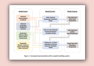
Developed decision support tools, including a mechanistic model of water temperature and a forecast tool for water temperatures on the Yampa River through Steamboat Springs. Used the mechanistic model to evaluate the impact of various riparian restoration and water management strategies on reducing elevated water temperatures in the late summer and fall. Generated a set of evaluative criteria and a workflow employing the water temperature forecast tool to inform reopening decisions following a recreational river closure. Continue to support the City in data collection and analysis tasks related to the development of a site-specific water temperature standard on the Yampa River.
Streamflow Impacts of ATM Projects
Trout Unlimited, TNC, American Rivers
Monitored and analyzed the impacts of water conservation projects on patterns of streamflow on the Colorado River and Pass Creek near Kremmling, Colorado. Performed repeat synoptic streamflow measurements bracketing parcels where split-season or full-season fallow was implemented. Integrated on-farm evapotranspiration monitoring and diversion records to develop a farm-scale water balance model. Performed a sensitivity analysis with the model. Developed a web interface for the model to allow staff at Trout Unlimited, TNC, American Rivers, and other organizations to estimate impacts of water conservation on streamflows in different settings.
Lagged Groundwater Response to Floodplain Inundation
American Rivers
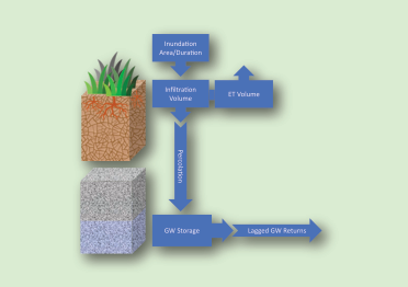
Assessed the impact of lagged return flows associated with managed floodplain inundation at select sites along the Crystal River near Carbondale, Colorado. Developed a numerical soil water infiltration and groundwater return flow model to predict the impact of transient floodplain inundation on the magnitude and timing of groundwater accretions to nearby stream segments. Assessed outcomes against needs for water rights augmentation. Recommended a monitoring regime for each site that could be used to refine groundwater return flow predictions and validate post-project impacts.
Yampa River Hydrological Model Uncertainty and Data Needs
River Network
Evaluated StateMod model uncertainty in streamflow and prioritized river segments for additional streamflow measurements across the Yampa Basin. Developed a multi-factor prioritization approach that incorporated observational and simulated uncertainty, ecologic risk and management priorities. Incorporated water rights analysis to assess potential for in-stream flow rights to supply streamflow during low flow periods. Generated static and web-based interactive reports with data visualizations including maps and figures that supported recommendations.
Filoha Meadows Groundwater Assessment
Pitkin County Open Space and Trails
Conducted a hydrological groundwater assessment of a degraded meadow parcel adjacent to the Crystal River. Evaluated groundwater conditions and generated relative elevation models of the riparian corridor. Assessed the hydrologic suitability of the parcel for cottonwood restoration.
Community Water Plan
Eagle River Watershed Council
Worked with stakeholders in the Eagle River Watershed to develop a shared community vision of water use and management under different climate and water demand futures. Led the technical work on the project, which included: 1) assessment of ecosystem condition, development of environmental flow needs, and evaluation of recreational use preferences, 2) characterization of the type and location of environmental and recreational attributes at risk, 3) identification of collaborative opportunities for projects and processes that support the diversity of use needs present in the basin, and 4) evaluation and prioritization of the relative effectiveness and feasibility of each identified opportunity.
Characteristics and Behavior of River Form on the Yampa River at Morgan Bottom
The Nature Conservancy
Identified restoration and conservation actions in Morgan Bottom that are most likely to yield durable and sustained returns on initial project investments throughout the lower Yampa River. The prioritization of potential actions considered the local and regional fluvial geomorphological context; the hydrological regime, lateral channel migration, and land use change. Final reporting deliverables included a description of the risks and opportunities associated with various restoration and/or water management actions intended to promote ecological integrity and improve the resiliency of agricultural water use infrastructure.
Network Connectivity for Native Fishes in the San Juan River Basin
The Nature Conservancy
Assessed key limiting ecological factors for native trout and native warm water fish in the upper San Juan River Basin (SJRB). Lotic performed an analysis focused on the critical role that network connectivity plays in mediating the resiliency of these populations. Over the course of the project, Lotic staff engaged with TNC staff, resource management agency staff, and other stakeholders, completed a set of network-oriented connectivity analyses, and developed a formalized strategy for using technical analysis results to rank and prioritize identified gray and green infrastructure projects. The project generated information that will help TNC and other stakeholders in the SJRB systematically implement infrastructure design improvements, alternative water operations, and other site-specific projects in locations and in sequences that maximize beneficial outcomes.
Thompson Creek Open Space Floodplain Restoration Concept Plan
Pitkin County
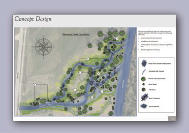
Developed a conceptual restoration plan for the Thompson Creek Open Space in Pitkin County. Proposed restoration activities were designed to increase ecological lift, as assessed by the FACWet framework. Developed hydraulic models to evaluate the impact of side channel creation, floodplain grading, and installation of woody debris structures on surface water and groundwater. Communicated modeling outcomes and proposed actions in a visually appealing strategic plan intended to speak to a broad non-technical audience.
Penny Hot Springs River Access Plan Review
Pitkin County
Provided hydrological and hydraulic design review services for Pitkin County Open Space and Trails on a project intended to improve access to public hot springs along the Crystal River. Contemplated the impacts of various design components on local river hydraulics and on riparian ecology. Provided recommendations for design modification.
Riparian Health Assessment
City of Aspen
Evaluated the functional characteristics of the riparian areas along the Roaring Fork River through Aspen, Colorado. The assessment approach followed a modified version of the Colorado Natural Heritage Program Ecological Integrity Assessment protocol. Worked with local stakeholders to identify acceptable opportunities to protect existing riparian areas and improve degraded areas. Provided City of Aspen staff with a prioritized list of policies, projects, and management actions for improving the water quality buffering capacity of the riparian corridor.
Crystal River Streambank Stabilization
Pitkin County Open Space and Trails
Developed design concepts, construction drawings, and documentation for stabilization of a 600' section of streambank on the Crystal River near Carbondale, Colorado. Ongoing erosion of the streambank endangered irrigation water delivery infrastructure, a bike path, and a state highway. Design elements aimed to strike a balance between infrastructure risk reduction and maintenance of important ecological and aesthetic characteristics of the site.
Stream Temperature Modeling Review
Grand County
Conducted a review of a proposal for stream temperature modeling submitted to Grand County and the Learning By Doing partnership by Denver Water. Evaluated the ability of the selected modeling approach to provide robust and reliable validations of the effectiveness of Denver Water's bypass flows for reducing stream temperatures in Ranch Creek and the Fraser River near Fraser, Colorado.
Environmental Flow Management Decision Support for the Fryingpan River
Roaring Fork Conservancy
Investigated water releases from Ruedi Reservoir that support multiple water uses on the Fryingpan River. Conducted an exhaustive review of published reports and data sets, hosted conversations with staff at Colorado Parks and Wildlife, Roaring Fork Conservancy, the Ruedi Water and Power Authority, City of Aspen, Colorado Water Conservation Board, Colorado River Water Conservation District, and the Bureau of Reclamation. Performed new analyses and meta-analyses to identify important environmental flow targets and the degree of risk to aquatic communities when those targets are unmet or exceeded during different seasons and under different drought or flood conditions. Constructed a water temperature predictive model for the Roaring Fork River at Glenwood Springs that allows water managers to evaluate the potential cooling effects of Ruedi Reservoir releases given short-term predictions for streamflows and maximum daily air temperatures.
Capitol Creek Decision Support System
Capitol Creek Caucus
Developed a hydrological and water rights decision support system for water users in the Capitol Creek watershed near Basalt, Colorado. The decision support system included a coupled hydrological simulation model and ecological response models designed to help water users and other local residents understand how patterns of surface water diversion and return flow influence ecological characteristics of Capitol Creek during wet, average, and dry year types. The Caucus was provided with recommendations for implementing efficiency measures and water conservation projects, based on outputs from the decision support system.
Big Sky Gauging Network Telemetry System Upgrade
Gallatin River Task Force
Provided technical assistance and communications system design review on a network of stream gauging and weather stations in the vicinity of Big Sky, Montana. Identified existing communication system failures, recommended system upgrades, and installed new equipment. Developed a data management workflow to facilitate meteorological and streamflow data archival and publication.
Riparian Monitoring Plan Review
Grand County
Conducted a review of a riparian monitoring plan submitted to Grand County as per a requirement in the 1041 permit for the Windy Gap Firming Project. Assessed the appropriateness of monitoring locations, frequency, and metrics against the intentions for post-project monitoring expressed by Grand County and the Northwest Colorado Council of Governments during the 1041 hearing process.
North Star Fen Wetland Restoration
Pitkin County Open Space and Trails
Conducted a hydrological assessment of a degraded fen wetland near Aspen, Colorado. Identified primary sources of ongoing impairment to fen characteristics and function. Developed a restoration plan for the fen that included development of several flow dispersion and grade control structures. Assisted in securing local and regional permits for implementation of the restoration plan.
Integrated Water Management Plan
Middle Colorado Watershed Council
Worked with stakeholders in the Middle Colorado Watershed to develop an Integrated Water Management Plan that considered: water quality issues that could be exacerbated by reduced flows; designation of critical habitat for the three federally-listed threatened or endangered fish; three native fish species of concern (roundtail chub, bluehead sucker, and flannelmouth sucker) that require management actions to ensure that populations do not decline to the point requiring a Threatened and Endangered Species listing; aquatic habitat degradation and the resulting need to protect water quality and riparian habitat along the Colorado River; and secondary impacts to tourism and the recreational economy.
Hayden Pass Fire Post-Fire Flood Risk Assessment
Upper Arkansas Water Conservancy District
Developed a rainfall-runoff model to predict post-fire streamflows for a 10-year rainfall event in the Big Cottonwood Creek drainage near Coaldale, Colorado. Calibrated the model using outputs from a 1-dimensional hydraulic model that characterized an observed flood event on August 25th, 2018. Rainfall intensity/duration observations for the same event, existing land cover and topographic characteristics, and peak streamflow estimates were used to subsequently calibrate interception, evaporation, infiltration, and streamflow routing parameters in a semi-distributed rainfall runoff model.
Cucharas River Post-Fire Flood Risk Assessment
La Veta School District
Developed a set of 100- and 500-year post-fire flood flows for Middle Creek and the Cucharas River near La Veta, Colorado. Statistically characterized observed flood events at existing streamflow gauges on the Cucharas River. Estimated the rainfall driven flood magnitudes sourced from the areas of the Cucharas River watershed above Middle Creek that were affected by the Spring Creek wildfire. Observed and modeled flood conditions were considered jointly to estimate 100- and 500-year flood flows on the Cucharas River.
Roaring Fork Stream Gauge
Aspen Center for Environmental Studies
Installed, calibrated, and maintained a streamflow gauge on the Roaring Fork River near Aspen. Streamflow monitoring results are primarily used as an outreach tool by local conservation organizations.
Framework for Integrated Water Management Planning
Colorado Mesa University, Colorado Basin Roundtable
Developed an organizational and methodological framework for integrated water management planning in the Colorado Basin. The final deliverable has become a widely used guidance document for integrated water management plans developed across the state of Colorado.
Yampa River Stream Management Plan
City of Steamboat Springs
Implemented the Stream Health Assessment Framework to identify and prioritize constraints on ecological function in the section of the Yampa River that flows through Steamboat Springs. Evaluated conditions for channel morphology, hydrologic regime behavior, riparian health and extent, water quality, and aquatic biota. Worked with city staff, NGOs, water resource management agencies, and other stakeholders to identify alternative projects and processes that may help alleviate problematic conditions. Assessed likely outcomes of each alternative to develop a prioritized restoration, conservation, and water management plan for the City of Steamboat Springs.
Upper Colorado River Basin Resource Guide
Colorado Mesa University, Colorado Basin Roundtable
Developed a data visualization dashboard for presenting diverse hydrological, water quality, water rights, and aquatic biota data in an interactive web application. Worked with stakeholders from the Colorado Basin Roundtable to determine likely user workflows and data needs. Leveraged existing Colorado Decision Support Tools (CDSS) and simulation modeling projects to support efforts to identify locations in the basin in need of focused planning around environmental and/or recreational needs.
Upper Roaring Fork River Stream Management Plan
City of Aspen and Pitkin County
Synthesized existing research, characterized environmental and recreational use needs, and evaluated management opportunities for meeting those needs on the Upper Roaring Fork River near Aspen. Considered channel maintenance flows, riparian conditions, aquatic habitat quality and connectivity, and recreational use preferences. Managed a team of consultants, including aquatic biologists, water rights experts, and a dialog facilitation organization to implement the planning effort. Planning outcomes will inform management of City and County owned properties and water rights, development of policy and regulations, and participation in other regional water planning efforts (e.g. Twin Lakes Exchange) with diverse groups of stakeholders.
Upper Rio Grande Watershed Assessment
Rio Grande Headwater Restoration Project
Worked on a team to produce a watershed assessment document for the upper Rio Grande watershed. Assessment efforts included characterization of fire risk, assessment of geomorphic vulnerability of different stream segments to altered sediment or hydrological regimes, characterization of riparian condition, water quality, fisheries health, and several other aspects of watershed health. The resulting document contains numerous large format maps and a set of recommended management priorities that responded to stakeholders' desire to protect vital infrastructure, enhance or protect river health, and ensure adequate access to rivers for recreational users.
St. Vrain and Lefthand Creek Boatable Days Analysis
American Whitewater
Conducted a Boatable Days analysis from user survey data and hydrological simulation outputs from Lefthand Creek and the St. Vrain River. Identified acceptable and optimal flows for various recreational uses. Computed the average number of days falling within each range under wet, average, and dry year types. Outputs were incorporated into the St. Vrain and Lefthand Stream Management Plan.
Rio Grande Boatable Days Analysis
American Whitewater
Conducted a Boatable Days analysis from user survey data and hydrological simulation outputs from the Rio Grande River and the Conejos River. Identified acceptable and optimal flows for various recreational uses. Computed the average number of days falling within each range under wet, average, and dry year types. Outputs were incorporated into the Rio Grande Stream Management Plan.
Crystal River Stream Gauging Network
Roaring Fork Conservancy
Developed a network of stream gauges on the Crystal River near Carbondale, Colorado. Installed, calibrated, and maintained three radar sensor staff gauges that communicated over a cellular telemetry network. Developed a custom communication code-base to push data to the State of Colorado's Hydrobase repository for data archival and display.
San Miguel Pilot Project
Trout Unlimited
Prototyped an approach for assessing non-consumptive use needs and evaluating management opportunities for meeting those needs in Colorado's Southwest Basin using the San Miguel watershed as a test-case. Considered channel maintenance flows, riparian conditions, aquatic habitat quality and connectivity, and recreational use preferences. Used field data to develop and refine hydrological and hydraulic simulation models that characterize existing conditions and enable evaluation of 'what-if' scenarios. Engaged stakeholders to guide selection of management opportunities for evaluation in the assessment framework. Planning outcomes intend to instruct future water planning, granting and approval processes.
Crystal River Stream Management Plan
Roaring Fork Conservancy
Produced a guidance document for implementing high-priority projects and executing feasible water resource management alternatives in the Crystal River watershed aimed at addressing late season low-flow conditions that impair stream health. Results from this effort identified, prioritized, and provided initial project scoping for alternative management actions and/or structural solutions available to improve ecological conditions and functions in the Crystal River while recognizing the management constraints imposed by the competing objectives of various local stakeholder groups.
Eagle River Water Quality Monitoring and Assessment Program
Eagle River Watershed Council
Coordinated water quality monitoring and assessment activities, provided data interpretation and technical assistance to local governments and resource managers, identified data gaps, and suggested actions to remedy perceived water quality impairments in the Eagle River watershed. Compiled annual technical reports assessing current water quality conditions and trends. Coordinated watershed-wide data collection efforts among multiple agencies to maximize efficiency and fill data gaps. Engaged stakeholders and the general public to enhance community-wide understanding of water quality issues. Developed a long-term water quality monitoring plan for data collection entities within the watershed.
Brush Creek Health Summary
Roaring Fork Conservancy
Evaluated the aquatic life and riparian health characteristics of Brush Creek near Snowmass Village, Colorado. Evaluated primary sources of water quality impairment. Provided recommendations for further data collection and measures that would be protective of aquatic life.
Wolcott PUD 1041 Permit Application Review
Eagle River Watershed Council
Conducted a review of a 1041 permit application for a Planned Unit Development (PUD) in Wolcott, Colorado. Evaluated the sufficiency of stormwater infrastructure and other components of the plan related to water quality impact/protection. Provided recommendations for conditional permit approval to Eagle County.
Learning By Doing
Northwest Colorado Council of Governments
Participated in an adaptive management program to operate Denver Water's Moffat transmountain diversion system in a manner that mitigates and enhances environmental conditions in the Fraser and upper Colorado River basins. Developed annual operating plans, reviewed stream condition monitoring results and prioritized restoration projects.
Water Quality Sampling and Analysis Plan
City of Aspen
Developed a guidance document and set of standard operating procedures for assessing long-term water quality trends on the Roaring Fork River, estimating event mean concentrations for various pollutants in stormwater discharges, and identifying illicit discharges and other water quality impairments within the City of Aspen.
Gore Creek Strategic Action Plan
Town of Vail
Developed a strategic action plan for addressing observed water quality impairments on Gore Creek near the Town of Vail. Evaluated and prioritized an array of tasks that fell within five primary categories: education and outreach campaigns, regulatory changes, implementation of best management practices, streambank restoration and structural BMP projects, and ongoing data collection and study.
Snapshot Assessment of Two Distressed Rivers
Roaring Fork Conservancy
Collected synoptic measurements of streamflow and water quality on the Roaring Fork River through the City of Aspen and the Lower Crystal River near Carbondale over several dates in late summer during severe drought conditions. Analyzed data to elucidate relationships between longitudinal changes in streamflow, water temperature, and other easily measured water quality parameters during late-summer baseflow. Identified several dates/locations on both study segments where existing management decisions severely deplete streamflows during drought.
Lower Crystal River Assessment
Roaring Fork Conservancy
Constructed a water rights allocation and accounting simulation model for surface water in the Lower Crystal River. Simulated daily streamflow conditions during average, moderate drought, and severe drought conditions in association with several alternative water conservation scenarios. Identified longitudinal patterns in stream discharge produced by each environmental condition and management scenario pairing. Formatted results for input into a framework for assessing ecological benefits of alternative water management scenarios.